Winds & Temperatures Aloft
Winds and Temperatures Aloft forecasts help pilots evaluate conditions at altitude for flight planning and performance calculations.
Introduction to Winds & Temperatures Aloft
- Winds and Temperatures Aloft, also called "FBs," are computer-prepared forecasts for specific locations in the contiguous U.S. and a network of locations in Alaska and Hawaii.
- These forecasts (versus observed) aid pilots in the planning and execution of cross-country (non-local) flights by providing wind direction, wind speed, and temperatures at specified times, altitudes, and locations.
Winds & Temperatures Aloft Key Highlights
- Winds and temperatures aloft forecasts provide expected wind direction, wind speed, and temperature information at selected altitudes.
- Pilots use winds aloft data to calculate headings, groundspeed, fuel burn, estimated time en route, and aircraft performance.
- Forecast wind direction is reported in degrees true, while wind speed is reported in knots.
- Temperature aloft information helps pilots evaluate aircraft performance, icing potential, and high-altitude operating conditions.
- Winds aloft forecasts support route planning by helping pilots identify favorable tailwinds or avoid strong headwinds.
- Significant wind changes with altitude may indicate wind shear, turbulence, or changing weather patterns.
- Pilots should compare forecast winds aloft with actual groundspeed, weather reports, and updated forecast products during flight.
- Forecast data is issued for specific reporting locations and altitude levels, requiring interpolation for routes between stations.
- Accurate interpretation of coded winds and temperatures aloft improves fuel planning, navigation accuracy, and operational efficiency.
- Understanding winds and temperatures aloft improves weather analysis, flight planning, and overall aeronautical decision-making.
Winds & Temperatures Aloft Purpose
- Various models culminate in the winds and temperature aloft forecast.
- Pilots need to know how to read winds and temperatures aloft charts and graphics to aid in planning.
- While cross-country flight planning and execution are primary reasons pilots look at winds and temperatures aloft, these reports can also apply to local flights.
- Specifically, winds & temperatures aloft forecasts aid pilots in:
- Determining the most favorable altitude based on winds and the direction of flight.
- Provide data with which to calculate aircraft performance (fuel consumption, time of flight, etc.).
- Identifying areas of possible aircraft icing by noting air temperature of +2°C to -20°C, and temperature inversions.
- Predicting turbulence by observing abrupt changes in wind direction and speed at different altitudes.
Winds & Temperatures Aloft Issuance & Validity
-
Winds & Temperatures Aloft Issuance:
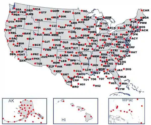
- Winds and temperatures aloft are issued in both textual and graphical formats, covering nine distinct regions: (6 CONUS and 3 OCONUS): []
- Winds & temperatures aloft (FB) forecasts are produced by the NWS National Centers for Environmental Prediction (NCEP).
-
Textual Winds & Temperatures Aloft:
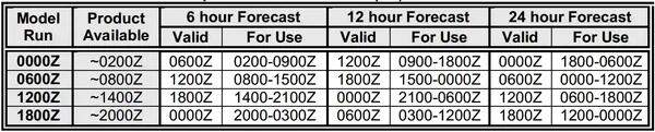
- FB charts are issued four times daily (every six hours), valid for the time stated on the winds aloft chart.
-
Graphical Winds & Temperatures Aloft:
- NWS' Rapid Refresh model winds are updated every hour.
- Provide values at grid points as close as 9 NM.
-
Winds & Temperatures Aloft Validity:
- Amendments are not issued to winds aloft forecasts. []
- Data can therefore be up to six hours old.
- If the scheduled forecast is delayed, the existing valid forecast based on the earlier 6-hourly data can be used until a new forecast is transmitted.
- Amendments are not issued to winds aloft forecasts. []
Winds & Temperatures Aloft Forecast Elements
- Pilots can locate textual reports on the Aviation Weather Center Website under the "Products"/"Wind/temp data" drop-down.
- Textual and graphical formats are available.
-
Textual Winds & Temperatures Elements:
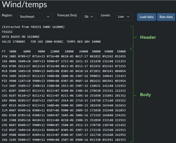
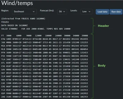
- Textual Wind and Temperature Aloft forecasts consist of two elements: the header and the forecasted data chart. []
-
Textual FB Header:
- "FD" indicates a wind and temperatures aloft forecast.
- "FD1US1" is a standard line regardless of the reported region.
- The date and time group (DTG) of data collection is listed.
- "DATA BASED ON: 131800Z:" Data is presented based on the 13th day of the month, 1800Z.
- Valid at the "FOR USE" times listed.
- "FOR USE: 2000-0300Z:" for use between 2000Z and 0300Z.
- "TEMPS NEG ABOVE 24000" is a standard line.
- Since temperatures above 24,000' are always negative, reports omit the negative ("-") sign.
-
Textual FB Forecasted Data (body):
- Winds & temperature forecast data for 3000, 6000, 9000, 1200, 18000, 24,000, 30000, 34,000, and 39000 feet.
- Hawaii and the Western Pacific data include winds for 1,000, 1,500, and 2,000-foot altitudes.
- "FT" indicates the levels of the wind and temperature data.
- A four-digit group shows wind direction in tens of degrees, and the second two are wind speed in knots.
- Altitude data up to and including 15,000 feet are true altitudes (references to MSL).
- Altitude data at or above 18,000 feet are pressure altitudes (references to FL).
- The symbolic form of the forecasts is DDff+TT, in which:
- DD is the wind direction (True North).
- ff the wind speed (knots).
- TT the temperature (Celsius).
-
Forecasted Winds Aloft:
- No winds forecasted within 1,500' AGL of station elevation.
- Forecasted winds display in tens of degrees (two digits) from True North with wind speed in knots (two digits).
- 2022: 200@22 knots.
- If forecasted wind speeds are to be less than 5 knots, the wind group reads 9900, which means "light and variable."
- 990012: winds are light and variable, temperature 12°C.
- If forecast speed is greater than 100 knots, add 100 from the wind speed and subtract 50 to the wind direction.
- 731960:
- Step 1: 73-50 = 23 or 230.
- Step 2: 19 + 100 = 119.
- Result: 230@119 (temperature -60°C).
- 731960:
- If forecasted wind speeds are to be 200 knots or greater, the wind group reads 99 knots.
- 189960: 180@200+ (temperature -60°C).
-
Forecasted Temperatures Aloft:
- Forecasts omit temperatures within 2,500' AGL of station elevation.
- A six-digit group includes forecast temperatures in degrees Celsius.
- 192832: The last two digits show 32°C for the temperature, but remember that above 24,000 feet, reports exclude the negative ("-") sign.
- Winds & temperature forecast data for 3000, 6000, 9000, 1200, 18000, 24,000, 30000, 34,000, and 39000 feet.
-
Graphical Winds & Temperatures Aloft Reports:
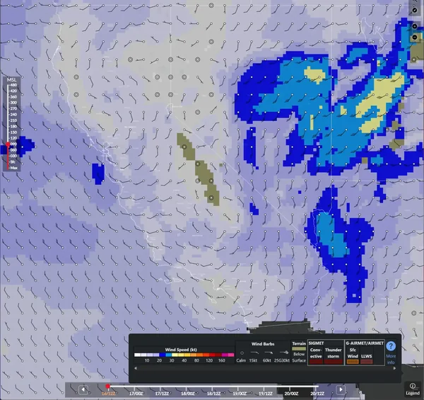
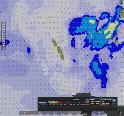
- Pilots can locate graphical winds and temperatures aloft forecasts on the Aviation Weather Center's Website under the "Weather/Winds/Temperatures" drop-down. []
- The graphical chart displays various layers simultaneously or not at all.
- An altitude chart allows the pilot to select the desired altitude for viewing forecasted data.
- A validity bar allows the pilot to read the forecast data timeframe in the standard 6-hour increment.
-
Graphical Forecasted Winds Aloft:
- Wind data displays with a wind flag and a "heat map." [/]
- Don't misinterpret the term heat map or the color display to represent temperatures when only viewing winds.
-
Interpreting Wind Flags:
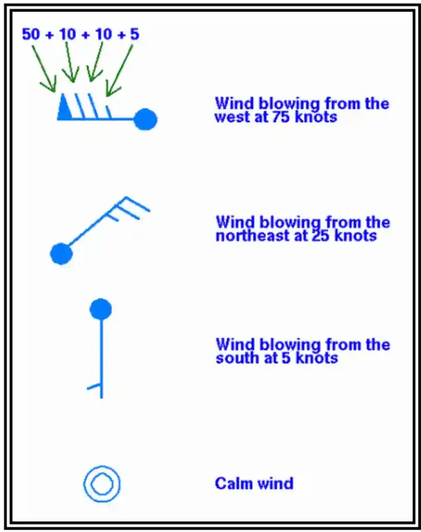
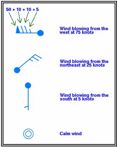
- A point depicts stations from which a line extends.
- The line represents the direction of the wind (i.e., follow the line down to the station for direction).
- At the end of the line are barbs with a short line indicating 5 knots, a longer line indicating 10 knots, and a triangle indicating 50 knots.
- Wind barbs are additive, so two long lines are 20 knots.
- If no flag is present, winds are calm (less than 5 knots).
- Gusts, if forecast, are written at the end of the flag with the letter G to represent gusts and the number reflecting speed in knots.
-
Interpreting Wind Speeds:
- A heat map overlay provides wind speed data at a glance, especially over vast areas.
- The brighter the color, the higher the wind speed.
- Terrain displays in those mountainous areas at elevations higher than those selected by the elevation slider.
- Clicking on the station also provides the wind direction and wind speed forecast at that station.
- Unlike the textual report, which provides winds at 1,000, 1,500, and 2,000 feet for Hawaii and the Western Pacific, the graphical tool elevation chart does not display below 3,000 feet.
-
Graphical Forecasted Temperatures Aloft:
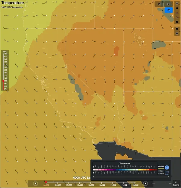
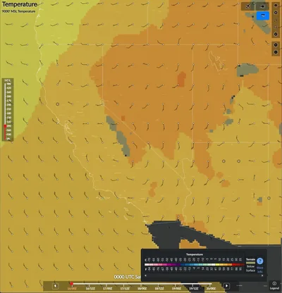
- Temperature data displays with a color map (legend in the bottom right of the web tool). []
- Unlike wind flags, temperature data displays with colors only per the legend.
- Wind data displays with a wind flag and a "heat map." [/]
Winds & Temperatures Aloft Knowledge Check
Private Pilot

Core Knowledge Review
Review the foundational knowledge, key concepts, and practical considerations for Winds & Temperatures Aloft.
Foundational
Immediate Feedback
Answer Explanations
Commercial Pilot

Advanced Application
Apply your knowledge of Winds & Temperatures Aloft to advanced operational scenarios, risk management, and aeronautical decision-making.
Advanced
Scenario Based
Risk Management
Why Take a Quiz?
Quizzes reinforce key concepts, identify knowledge gaps, and build confidence for real-world decisions in the cockpit.
Winds & Temperatures Aloft Interactive Scenario
Interactive Scenario
Loading scenario details...
Decision 1
0%
Scenario Complete
Winds & Temperatures Aloft Conclusion
- The winds & temperatures aloft forecast chart provides a concise means to interpret winds across a wide span of locations and altitudes.
- Pilots need to learn how to read wind and temperature aloft forecasts, primarily for longer-distance flight planning, but occasionally for local flights as well.
- For more information, a paper copy of the Federal Aviation Administration (FAA-H-8083-28) Aviation Weather Handbook [Amazon] is available for purchase.
- A digital copy of the Federal Aviation Administration (FAA-H-8083-28) Aviation Weather Handbook is available from the FAA's website.
- Textual reports provide simple, low-bandwidth solutions for pilots, while graphical reports are more interactive and intuitive, especially over wide areas.
- Winds and temperatures aloft have long validity times for conditions that can often fluctuate.
- Consider cross-checking wind readings with the Velocity Azimuth Display (VAD) winds.
- Winds and temperatures are not forecasted within 1500 and 2500 feet, respectively, meaning these blocks will appear blank for some stations in mountainous areas.
- Check out the aircraft icing and atmosphere pages to learn more about how winds and temperatures aloft is applied.
- Improve your weather skills with FAA-provided (and WINGS-credited) resources by going to https://www.faasafety.gov/ and typing "weather" into the search bar.
- Still looking for something? Continue searching:
Winds and Temperatures Aloft References
- Federal Aviation Administration (FAA-H-8083-28) Aviation Weather Handbook.
- Federal Aviation Administration - Pilot/Controller Glossary.
- National Weather Service (NWS) National Centers for Environmental Prediction (NCEP).
- North American Mesoscale (NAM).
- Wikipedia - Inversions.
- World Meteorological Organization (WMO).